
Workpackages WP8-WP15
- WP8 - Impacts and costs: air pollution and health
- WP9 - Vulnerability, risks and adaptive capacity: water, energy, tourism and infrastructure
- WP10 - Vulnerability, risks and adaptive capacity: forestry, agriculture and ecosystems
- WP11 - Cross sector assessments and synthesis for Europe
- WP12 - Impact, vulnerability and adaptation in most vulnerable regions: African Case study
- WP13 - Impact, vulnerability and adaptation in most vulnerable regions: Bangladesh Case Study
- WP14 - Impact, vulnerability and adaptation in most vulnerable regions: Small Islands (the Maldives)
- WP15 - Outreach, training and dissemination
Provide projections of the impact of the 1.5°C and 2°C climate change on health, including air pollution effects, in physical terms and as economic costs.
- Provide long-term pan-european gridded simulations of recent climate air quality pollutants (Ozone (O3), nitrogen dioxide (NO2), particulate matter (PM10 and PM2.5)) over the past 20 years, their projections under a “2°C climate” given a few compatible air pollutant emission scenarios, and the associated uncertainties.
- Identify uncertainty and assess adaptation options including costs and benefits.
Participants
CNRS-IPSL (lead)
MET.NO, SMHI, MeteoF, PWA, WHO
Main objectives
In addition to impacts and costs modeling of a global mean temperature increase of 2°C in WP6, this WP follows a purely risk oriented approach for the same sectors by generating established risk indicators such as Value at Risk (VaR). On the basis of a comprehensive damage data collection, by using advanced methods from actual science the results will be designed to maximize their usability for national and EU-wide risk transfer mechanisms and insurance. This focus on adaptive capacity as the EU’s societies’ capacity to financially manage the risks from climate change requires the employed risk measures to be compatible with current EU legislation, such as the SOLVENCY II (regulatory requirements for insurance firms) process. Also the concept of vulnerability in this WP necessarily deviates from that usually utilized and operationalised in climate impact studies, since it has to be compatible with the insurance perspective and strictly quantitative.
This WP will provide a sound scientific approach for estimating weather and climate risks and quantify the change in risk due to the changing climate signal by the above mentioned risk metrics. Bringing together state of the art techniques from stochastic weather index modeling, climate impact research and actual modeling of random phenomena, both aspects of risk (probability and impact) are assessed simultaneously.
Specific objectives
1. Determining the value of building infrastructure in EU 27 (27 EU Member States).
2. Determining the Value at Risk from Floods in EU 27 in conformity to Solvency SOLVENCY II .
3. Quantify the change of weather risk to electricity demand due to a change in the climate signal (2°C) for continental Europe.
4. Quantify the change of weather risk to demand for beach oriented summer tourism and snow oriented winter tourism due to a change in the climate signal (2°C) for tourism intensive NUTS III regions in EU 27.
5. Recommend reform steps for the financial risk transfer mechanism currently in place to increase adaptive capacity in EU 27.
Participants
JR (lead)
HZG, MET.NO, UniGraz, WU, TUC, UNIL
The impacts of +2 °C global warming on winter tourism demand in Europe
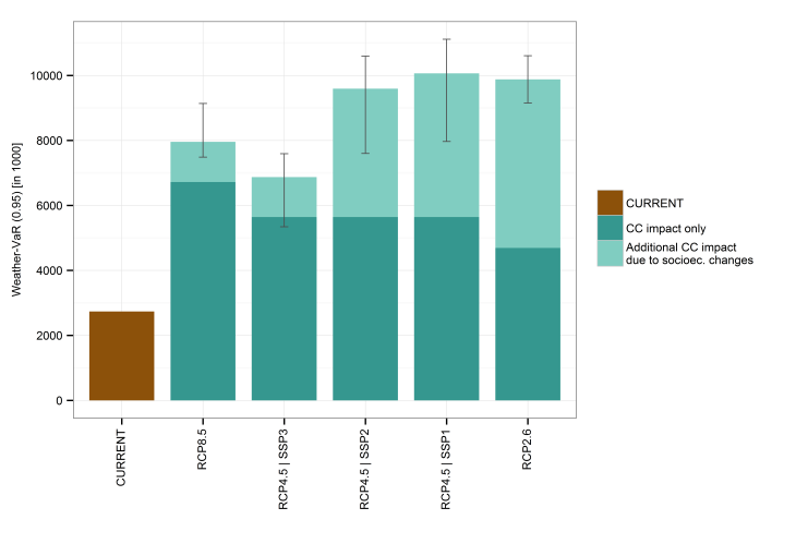
Figure 1: Aggregated Weather-Value at Risk (0.95) of winter overnight stays for all considered NUTS-3 regions in Europe. Error bars show the range of climate simulations (2 RCP2.6, 5 RCP4.5, and 4 RCP8.5). For RCP4.5 the impact of underlying Shared Socioeconomic Pathways (SSP 1 to 3) is shown in the different bars. For RCP2.6 simulations SSP1 and for RCP8.5 SSP3 is used.
We quantify the impacts of +2 °C global warming on winter tourism demand in Europe’s ski tourism related regions. Using time series regression models the relationship between natural snow conditions and monthly overnight stays is estimated. Based on these model results we quantify the risk of tourism demand losses due to weather variability and assess the potential impacts of climate change. Hereby, the concept of Weather-Value at Risk (Weather-VaR [α]) is applied, which represents for a given level of confidence (α) over a given period of time the maximum expected loss in winter overnight stays. Snow data are provided by the hydrological model VIC, which is forced by E-OBS data to obtain historical snow values for tourism model calibration and forced by EURO-CORDEX climate simulations to obtain snow projections until 2100.
Figure 1: Aggregated Weather-Value at Risk (0.95) of winter overnight stays for all considered NUTS-3 regions in Europe. Error bars show the range of climate simulations (2 RCP2.6, 5 RCP4.5, and 4 RCP8.5). For RCP4.5 the impact of underlying Shared Socioeconomic Pathways (SSP 1 to 3) is shown in the different bars. For RCP2.6 simulations SSP1 and for RCP8.5 SSP3 is used. Figure 1: Aggregated Weather-Value at Risk (0.95) of winter overnight stays for all considered NUTS-3 regions in Europe. Error bars show the range of climate simulations (2 RCP2.6, 5 RCP4.5, and 4 RCP8.5). For RCP4.5 the impact of underlying Shared Socioeconomic Pathways (SSP 1 to 3) is shown in the different bars. For RCP2.6 simulations SSP1 and for RCP8.5 SSP3 is used.
Figure 1 shows the aggregated Weather-VaR (0.95) of winter overnight stays for all considered NUTS-3 regions in Europe. Under +2 °C warming the weather-induced risk of losses in winter overnight stays related to skiing tourism in Europe amounts up to 10.1 million nights per winter season (not exceeded with a probability of 95 %), which is +7.3 million overnight stays additionally at risk compared to the reference period (1971-2000). Among the four ‘big players’ of European skiing tourism – Austria, France, Italy and Switzerland –, France and Switzerland show the lowest increase in risk of losses in winter overnight stays. The highest weather-induced risk of losses in winter overnight stays – in the reference period as well as in the +2 °C scenarios – is found in Austria followed by Italy. These two countries account for the largest fraction of winter overnight stays in skiing related NUTS-3 regions.
Development of a methodological approach aiming at combining climate vulnerability, adaptation and risk.
- Assessment and projection of adaptive capacity at different scales as a function of human, physical, economic, social and human capital inputs.
- Assessment of climate vulnerability and risk associated with a 2°C warming for forestry, agriculture and ecosystems services for key hazards (drought and heat wave, flood, forest fire, windstorm) on a pan-European level.
Participants
IIASA (lead)
HZG, JR
The objectives of this task are:
To consider impacts from a cross-sectoral perspective, i) undertaking cross-sectoral analysis to link the sectoral pan-European analysis ii) focusing on particularly vulnerable areas in Europe, especially those that are subject to multiple impacts where cumulative effects may arise and iii) in relation to cross-cutting themes to address issues in an alternative way to the traditional sector analysis (e.g. water, cities and the built environment).
The task will also bring the impacts, vulnerability and cross-sectoral information together in a synthesis, allowing the integration of all the study findings in a consistent way, to provide some of the key policy outputs, providing succinct overview of the project.
Participants
PWA (lead)
HZG, WU, TUC, SOTON, SEI-Oxford
Main objectives
This WP focuses on vulnerability assessment (exposure to climate change, sensitivity of the natural environment and society to climate change, adaptive capacity of the system) in African regions due to a global averaged surface temperature change of 2°C from pre- industrial level. This is explored through case studies for each of these various geographical and human contexts.
Specific objectives:
12.1 Evaluation of climate impacts on water resources, vegetation and crop productivity, energy production and flow regime of main rivers in North Africa and sub-Saharan Africa.
12.2 Improving adaptive management of the water resources (reservoir operation, irrigation) considering water quality and biodiversity.
14.3 Assessing the vulnerability of the system as basic information for sustainable improvement of water use and food production to be able to cope with climate change impacts increasing adaptive capacity.
12.4 Quantification and documentation of the uncertainties coming from either model inputs and/or model accuracy of impact predictions, crucial when being used to take emergency measures.
Participants
ENEA (lead)
PIK, SMHI, IWMI, WI, ACMAD
This WP focuses on climate change impact, vulnerability and adaptation due to a global averaged surface temperature change of 2°C from pre- industrial level for the Coastal regions of Bangladesh.
Participants
WU (lead)
HZG, SOTON, BCAS, IWM
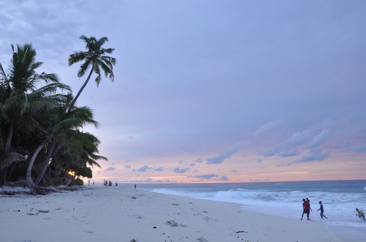
© Ahmed Shan, EPA, Maldives © Ahmed Shan, EPA, Maldives
This WP focuses on climate change impact, vulnerability and adaptation due to a global averaged surface temperature change of 2°C from pre- industrial level for the Coastal regions of Small Islands.
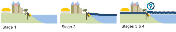
Small, low-lying islands have been seen as highly vulnerable to sea-level rise since the issue of climate-induced sea-level rise was raised in the 1980s. Regional assessments have highlighted potential impacts - in the worst case leading to forced migration - and subsequently high damage costs. Urbanisation and especially migration to the capital city is widespread: presently around a third of the national population live in the capital -- Malé, making it one of the most densely populated cities in the world with 50,000 people/km2. But, with rising sea levels how will the Maldives cope?
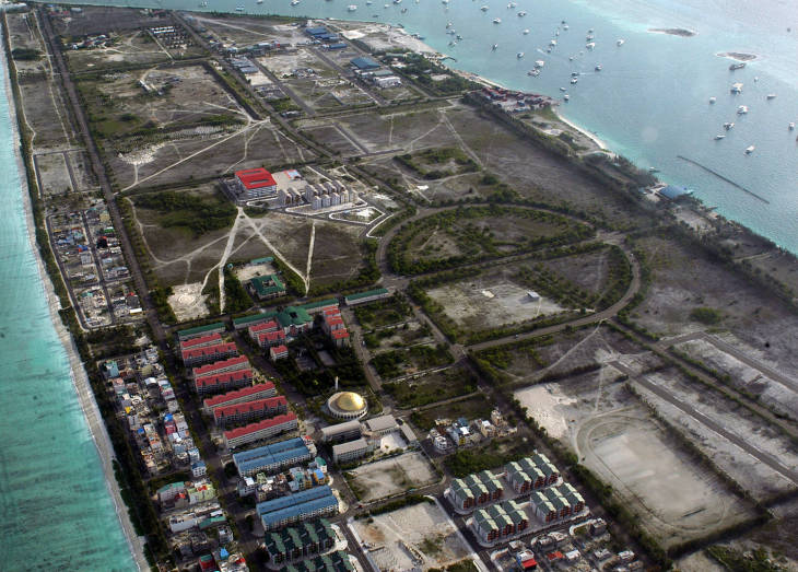
Hulhumale being developed to release the population pressure in the capital city of Male’. (From http://www.travelalltogether.com)
The Maldives comprises 1,192 low-lying coral atoll islands, located in the Indian Ocean, with elevations typically within 1-m of current high tides. 200 of the islands are inhabited. The islands are economically dependent on international tourism and fisheries. The Maldivian Ministry of Environment and Energy, together with the University of Southampton, UK and Global Climate Forum, Germany are assessing the impacts of sea-level rise, focusing on a relatively new artificial island, Hulhumalé.
Hulhumalé is a 200 hectare island claimed from a reef area during the late 1990s to relieve population pressure on the nearby capital city of Malé. Hulhumalé has experienced rapid and large population growth, reflecting the high demand for land and housing in this part of the Maldives. The island was built approximately 2m above mean high water, and has so far been safe from inundation.
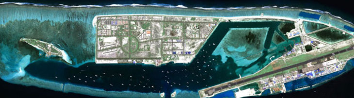
Hulhumalé is an entirely artificial island claimed over the reef flat and includes the main airport @ HDC
Our study considers if and when the island may experience inundation due to extreme sea-level events and/or wave overtopping, and when this may occur with rising sea levels. We are:
(1a) Collating land datasets to define land elevations and associated assets.
(1b) Collating oceanic datasets to determine the frequency of extreme events (sea levels and waves), and selecting appropriate sea-level scenarios.
(2) Using an overtopping model (SWAB) developed by the University of Manchester, UK to determine volume of overtopping for plausible present and future events.
(3) Investigating what parts of the island could be inundated using LISFLOOD.
(4) Determining what infrastructure and assets on the island are at risk.
Overtopping Model (SWAB)
Initial results indicate that relative sea-level rise from the tide gauge (extracted from PSMSL, 2014) nearby Malé is approximately 4mm/yr since 1990 – faster than the global average, although longer records are preferred. Globally, sea-level rise is expected to accelerate, with up to approximately 1m of rise by 2100 (taking a high-end scenario from Church et al. 2013). This trend would be expected in the Maldives. Mean Sea Level Malé, Hulule
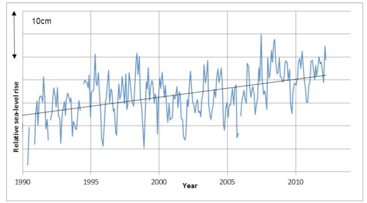
Relative sea-level rise in Malé. Data extracted from PSMSL (2014). Click picture to enlarge
Two particular events which caused flooding in 1987 and 2007 were due to long period energetic swell waves, the latter generated off the coast of South Africa. In the 2007 event, Malé was flooded, but Hulhumalé was flood free. Using this event as an example of an extreme event, we are assessing how overtopping could change with sea-level rise. Initial results suggest that under swell/surge conditions, it could take tens of centimetres of sea-level rise before overtopping occurs.
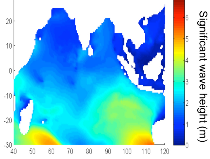
Example of significant wave heights in the Indian Ocean, May 2007 (data extracted from WaveWatchIII)
In our future work, we will better quantify our initial results, and also consider the role of adaptation. Adaptation, such as building sea walls or replenishing beaches could help to reduce impacts. As sea-level rise has significant inertia and will continue even if temperature rise stabilises (the so-called commitment to sea-level rise), we will consider changes beyond 2100 if possible.
Participants
SOTON (lead)
HZG, MHE, GCF
NOAA Wave Watch III
The main objective of this work package is to disseminate research results and to raise awareness of society and policy makers towards impacts of climate change and needs to act. In order to reach the different actors in society and decision makers, the project will provide end-user tailored project information, training and knowledge dissemination in different formats/approaches: The project will
- Stage summer schools for (young) scientists.
- Deliver (training) workshops, conferences and possibly side-events to promote the exchange of scientific results from IMPACT2C among scientists, stakeholders and multipliers, such as journalists.
- Facilitate the participation in the summer schools and workshops of all EU members as well as the non-European countries participating in the project.
- Develop a website with details on the IMPACT2C project, as well as the progress of the different WPs (in close cooperation with WP1).
- Generate project dissemination materials: Create an atlas of the main results of IMPACT2C (e.g. climate change, impacts, and vulnerability, risk and cost maps), provide headline news, policy briefs and fact sheets, and promote the submission of peer-review manuscripts concerning the results of IMPACT2C.
- Cooperate with the Media for dissemination.
Participants
HZG (lead)
all